 Over the past several years, remote sensing technology has witnessed tremendous growth.
The origin of remote sensing dates back to 1840 with the recording of photos of the ground using hot air balloons by using a camera.
Furthermore, aerial photography was used extensively as a reconnaissance tool during World War I, while the capabilities of remote sensing to track the enemy using radar, sonar, and infrared detection systems were better understood during World War II.
After WWII, scientists used advanced technology to expand remote sensing applications and planned to monitor and study the Earth from space.
The market for Earth observation satellites has since evolved dramatically and has been progressing with a constant upward graph. In fact, as per the latest report by BIS Research on the global satellite Earth observation data and services market, it is estimated to reach a value of $15.90 billion in 2032 at a growth rate of 6.92% during the forecast period 2022-2032.
In this article, we’ll go into the history of earth observation satellites and compare it with the current state of technology.
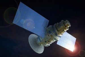
What Is an Earth Observation Satellite?
An Earth observation satellite, also known as an Earth remote sensing satellite, is a spacecraft used or developed for Earth observation (EO) from space. These include types such as spy satellites and related non-military applications including environmental monitoring, meteorology, mapping, and others.
Earth-imaging satellites are the most frequent type of observation satellite, which takes images similar to aerial photography; however, certain EO satellites may do remote sensing without producing images, such as in GNSS radio occultation.
Geographical information systems (GISs), image processing, machine learning, artificial intelligence, location, navigation, and timing have all improved the quality of image processing and analysis to deliver value-added services to a wide range of fields.
Most Earth observation satellites have passive sensors such as accelerometers, hyperspectral radiometers, imaging radiometers, sounders, spectrometers, and spectroradiometers that measure reflected or emitted solar radiation or thermal energy from the Earth's surface or through the atmosphere.
Furthermore, the most modern satellites have been fitted with active sensors such as a laser altimeter, lidar, radar, range instrument, and scatterometer.
A scatterometer generates energy and records the reflected return, which may be used to infer information about the Earth. The sensor's capabilities vary depending on the objective for which it was created.
Earth Observation Satellite Applications
- Weather Forecasting
A weather satellite is a kind of satellite used to track the Earth's weather and climate. However, these meteorological satellites see more than just clouds and cloud systems.
Other forms of environmental data obtained by weather satellites include city lights, fires, pollution impacts, auroras, sand and dust storms, snow cover, ice mapping, ocean current limits, energy flows, and so on.
- Environmental Monitoring
Changes in the Earth's flora, atmospheric trace gas concentration, sea status, ocean color, and ice fields may all be detected by other environmental satellites, which can help with environmental monitoring. Droughts may be tracked by comparing the present status of the plants to the long-term average.
- Mapping
Satellites such as Radarsat-1 and TerraSAR-X can be used to map terrain from space.
NISAR - New Advancements in Earth Observation Satellite
The NISAR (NASA-ISRO Synthetic Aperture Radar) is a cooperative mission between NASA and ISRO to develop an L-band polarimetric SAR and a S band polarimetric SAR.
The satellite is intended to be launched in 2022. With its low mass and vast surface area, the big SweepSAR antenna provides benefits over previous techniques, requiring lower transmitting power and a simpler array design.
It will capture all-weather day and night photos of the Earth's complete landmass and ice masses four to six times each month in polar LEO orbit, with pixel sizes ranging from 5 m to 10 m (25–100 m2).
This mission's primary goal is to track the Earth's changing ecosystems and dynamic surface (e.g., surface deformation, landslides, earthquakes, and ice masses).
It will track disasters and extreme weather events, such as droughts, forest fires, floods, hurricanes, and even insect outbreaks, to provide data for managing the state and health of the Earth's natural resources, such as plant biomass and changing hydrologic processes, such as sea level rise, glacier and ice sheet shifts, and groundwater alteration.
Conclusion
Satellites launched recently have demonstrated the capability of data processing, storage, measurement, and monitoring Earth's terrestrial, marine, and climatic environments, after more than 70 years of research.
Today, government agencies and other vital institutions have shown a strong interest in Earth observation satellites, with data being scrutinized.
Commercial operators and service providers have realized the enormous potential in data and images offered by Earth observation satellites as a result of constant technical improvement in the space sector and increased demand for satellite-based services.
This has resulted in new business models in which government agencies and private operators collaborate on national-level tasks such as weather forecasting, border monitoring, and natural resource surveys, among others.
About the Publisher: BIS Research is a global market intelligence, research and advisory company that focuses on emerging technology trends that are likely to disrupt the market. Its team includes industry veterans, experts, and analysts with diverse backgrounds in consulting, investment banking, government, and academia.